

The elliptical geometry of the bays implies that they originated as inclined conical cavities or penetration funnels. The bays are radially oriented toward the Great Lakes. For this reason, the Glacier ice impact hypothesis proposes that the Carolina Bays were created by oblique impacts of glacier ice ejected by one or more extraterrestrial impacts on the Laurentide Ice Sheet. If this is true, all the Carolina Bays formed contemporaneously. This episode discusses a method of dating the emplacement of the Carolina Bays using the geologic law of superposition and the established dates for the advance and retreat of the Laurentide Ice Sheet.
One of my YouTube subscribers sent me the coordinates of many features neatly organized in KMZ files for Google Earth. He had also done some research about the extent of the Laurentide Ice Sheet and pointed out that he did not find any bays in the area occupied by Lake Agassiz. He used as reference a paper published in 2023 by Professor Andrew Wickert from the University of Minnesota that has the latest calibration of the advance and retreat of the Laurentide Ice Sheet. I was impressed by the amount of work that had been done. I thought that besides evaluating the features, I could also explore the dating of the Carolina Bays relative to the advance and retreat of the ice sheet in Minnesota and Iowa.
This is not the first time that I try to establish a chronology of emplacement of the Carolina Bays relative to the extent of the ice sheets. In January of 2022, I examined the Carolina Bays in Long Island, New York. The island was created by accumulations of rock debris deposited by retreating glaciers during the Ice Age. The Ronkonkoma Moraine was emplaced about 55,000 years ago, and there are some Carolina Bays on top of this terrain.
A northern moraine, called the Harbor Hill Moraine, was formed after the retreat of the Wisconsin glacier, which reached its most southward advance about 18,000 years ago. This glacier completely melted in the New York City region approximately 13,000 to 12,000 years ago. Since Carolina Bays cannot form from impacts on top of an ice sheet, this means that the Carolina Bays in Long Island are younger than 55,000 years, and could even be younger than 18,000 years taking into consideration the newest data from Wickert.
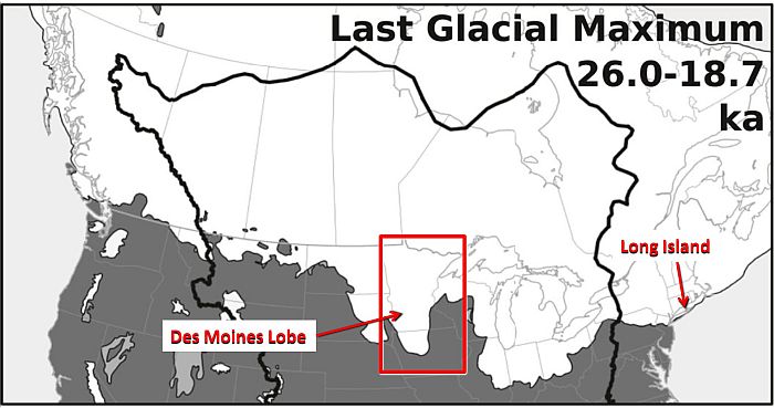
During the Ice Age, Canada was completely covered with ice. Canada's west coast was covered by the Cordilleran Ice Sheet and the central and eastern parts were covered by the Laurentide Ice sheet. The Laurentide Ice Sheet extended into the northeastern United States, and at its maximum extent the Des Moines lobe covered most of Minnesota and a large portion of northern Iowa.
A thesis by Sara Elizabeth Day published in 2014 assessed the advance and retreat of the Des Moines Lobe using LiDAR topographic data. The Des Moines Lobe, the largest of the lobes along the southern margin of the Laurentide Ice Sheet during the last glacial maximum, advanced south into a relatively warm, boreal climate. At its maximum extent at approximately 13,800 radiocarbon years before the present, the lobe covered more than 100,000 square kilometers in southern Minnesota and north-central Iowa and extended 600 kilometers beyond the main body of the Laurentide Ice Sheet, which covered Ames, Iowa. The lobe had retreated from Iowa by 11,700 radiocarbon years before the present.
The 2023 paper by Andrew Wickert and 7 co-authors says that twenty thousand years ago, a colder climate allowed glacial ice to flow from northern and eastern Canada into the Great Lakes region. But when the climate began to warm, instead of simply melting from south to north, the margin of the ice sheet front repeatedly retreated and re-advanced in 2,000-year cycles.
Wickert's paper illustrates five cycles of southward advances and northern retreats of the Laurentide Ice Sheet. The Last Glacial Maximum from 26,000 years ago to 18,700 years ago covered all of Canada and the northeastern United States with layer of ice that was almost three kilometers or two miles thick. The Last Glacial Maximum was followed by the Erie Retreat during which Lake Erie was not covered with ice. The Port Bruce advance covered all the Great Lakes with ice again and extended the Des Moines lobe over Minnesota and into Iowa. During the Mackinaw Retreat the Des Moines lobe almost disappeared.
The Port Huron advance restored the Des Moines lobe. The Great Lakes were covered with ice, except for the southern portion of Lake Michigan. An ice-free corridor opened between the Cordilleran Ice Sheet and the Laurentide Ice Sheet. During the Two Creeks Retreat only Lake Superior was completely covered with ice and a branch of Lake Agassiz divided North Dakota from Minnesota. The Onaway Advance kept Lake Superior and the northern parts of Lake Michigan and Lake Huron covered with ice. The ice-free corridor between the Cordilleran and Laurentide ice sheets continued to widen. During the Younger Dryas retreat, the Great lakes and all of the United States became ice free. Lake Agassiz became exposed and water started flowing toward the Atlantic Ocean through the St. Lawrence River. The Marquette Advance froze a portion of Lake Superior, but the Cordilleran Ice Sheet had completely disappeared by this time and Lake Agassiz was no longer covered with ice. During the Attibi retreat only the Hudson Bay area of Canada was covered with ice. The meltwater from all the glaciers starting from the Last Glacial Maximum until this time increased the sea level by one hundred meters. The sea would continue to rise an additional 20 meters until the ice over Canada melted.
The image from Wickert shows the Des Moines Lobe reaching half-way into Iowa during the Last Glacial Maximum from 26,000 to 18,700 years ago. Notice that at this time Long Island was covered with Ice. The Carolina Bays in Long Island must have formed after that. During the Port Huron advance, from 15,200 to 14,000 years ago, the Des Moines Lobe extended only into northern Iowa. Notice that by this time Long Island was no longer covered by the glacier. By 13,700 years ago, Minnesota and Iowa were no longer covered with ice.
Geologists develop the timelines of the ice sheets by dating the piles of rocks left by the melting glaciers. These piles of rocks are called moraines and they indicate the shape of the glaciers. Using LiDAR with colorized topography, the moraines appear almost like waves on the landscape. The margins of the glacier boundaries are gray lines that contrast against the broader areas with uniform colors on the terrain that was flattened by the passage of the glacier.
The Carolina Bays in Iowa are found to the southwest of the moraine left by the Port Huron advance that ended 14,000 years ago. This particular basin in Iowa was brought to my attention by Steven Arrasmith, and it has all the characteristics of a Carolina Bay. There are several Carolina Bays in this area, so this adds confidence to the characterization of the elliptical feature.
This map of Iowa shows the locations where the Carolina Bays were found. By overlaying a semi-transparent image of the Last Glacial Maximum from Wickert, we can see that all the Carolina Bays in Iowa are in the area that was covered with ice from 26,000 to 18,700 years ago. Notice that that the ice in Wickert's map does not advance as far south as in Sarah Elizabeth Day's map. This could be because Wickert's image does not have enough temporal resolution. Wickert's image represents a time period of 7300 years, and the Des Moines lobe could have advanced and retreated substantially during this time.
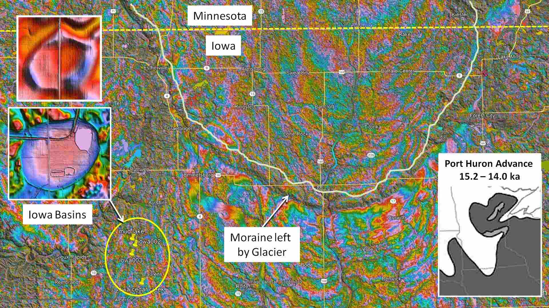
This LiDAR image highlights the moraine of the Des Moines Lobe in Wickert's illustration that marks the advance of the glacier during the Last Glacial Maximum. The movement of the glacier created some level terrain where Carolina Bays could form after the ice retreated. This means that the Carolina Bays in Iowa are younger than 18,700 years.
Now we will take a look at Carolina Bays in Minnesota. Most of the state was covered by the Des Moines Lobe during the Port Huron Advance between 15,200 and 14,000 years ago. During the Onaway Advance from 13,700 to 12,900 years ago, Minnesota was basically ice free. By this time, the melting glacier had formed Lake Agassiz and a branch of it divided Minnesota from North Dakota.
Minnesota is called the land of 10,000 lakes. Many of these lakes formed when blocks of ice detached from the glacier. Eventually, the blocks of ice became wholly or partially buried in sediment and slowly melted, leaving behind a pit. These pits are called kettles, and when the depressions are filled with water, they are called kettle lakes. These lakes vary in length, but they are usually shallow. In order to recognize Carolina Bays in this landscape, it is necessary to be very strict about identifying three major characteristics of the Carolina Bays: 1) elliptical geometry, 2) raised rims, 3) orientation toward the Great Lakes.
This feature is elliptical with a major axis of 872 meters and an azimuth of 236.8 degrees. All the points along the well-defined perimeter of this basin are exactly along the path of the ellipse. Unfortunately, this basin is keeping bad company. It has triangular, square and circular neighbors instead of other elliptical basins like the bays in North Carolina. This basin is also elliptical. It has a length of 591 meters and an azimuth of 235.3 degrees. The basin is connected to several irregular features. So its origin as an impact basin is not supported by its surroundings. This elliptical feature is on rough terrain and several fluvial channels and a road cross through the rim. The basin has a length of 824.7 meters and an azimuth of 236.6 degrees.
The three elliptical features in Minnesota have similar headings, but they do not point to the Great Lakes. These basins are oriented toward the Nastapoka Arc in Hudson Bay, which is a nearly perfect arc of a circle with a diameter of 450 kilometers. Oh, Oh. Why do I feel that I just opened a can of worms? The Nastapoka Arc has long been suspected of having been made by an extraterrestrial impact, but multiple investigations have failed to find any evidence of an extraterrestrial impact. We have to remember that there is no evidence of extraterrestrial impacts on the Great Lakes either, but there are many Carolina Bays and Nebraska Basins pointing toward them. It is possible that nobody knows what really happens when a comet crashes into an ice sheet.
The idea that some Carolina Bays are oriented toward the Hudson Bay area was previously suggested by Richard Firestone in a book published in 2006 and in a 2009 paper. Both, his book and his paper were severely criticized by opponents of the Younger Dryas Impact Hypothesis.
Finding just a few elliptical basins in Minnesota out of thousands of similar kettle lakes is not statistically reassuring. It is quite possible that these features are just kettle lakes that happen to be elliptical, and not impact basins like the Carolina Bays. The small number of basins cannot be used to make a convincing argument, but since the basins are on terrain that was covered with ice during the Port Huron Advance, we can conclude that they formed less than 14,000 years ago.
From the time that the bays were discovered, many geologists suggested that the Carolina Bays were formed by wind and water processes because the bays did not have shock metamorphism, meteorite fragments or other evidence of extraterrestrial impacts. Tests of the bays by Brooks and his colleagues using Optically Stimulated Luminescence produced a wide range of dates. The authors concluded that the Carolina Bays were created over thousands of years. The dates for Big Bay in South Carolina showed that the concentric sand rims representing previous shorelines became progressively younger toward the bay interior, and that a wind-blown sand sheet originating from the Wateree River on the west was moving over the bay 74,000 years ago and it was later modified 33,000 to 29,000 years ago.
Brooks and his co-authors say that: Based on 45 OSL dates, active shorelines and associated eolian deposition occurred during marine isotope stage (MIS) 2 to late MIS 3 (12 to 50 thousand years before the present), MIS 4 to very late MIS 5 (60 to 80 thousand years before the present), and late MIS 6 (120 to 140 thousand years before the present). These age ranges also correspond with the ages of other eolian landforms in the Coastal Plain, including sand sheets and dunefields, and suggest a climatic threshold was crossed during the transition toward stadials, initiating both bay and dune activity.
The LiDAR image of Big Bay has sharp enough margins to select points along the perimeter of the bay where it is not overlaid by the splash chevrons. Fitting an ellipse by the least squares method, we can show that Big Bay has a mathematically elliptical geometry. The features of this landscape can be interpreted from an impact perspective as follows. Ellipses are conic sections, so we can propose that the oblique impact of an ice projectile created an inclined conical cavity that became a shallow elliptical basin by viscous relaxation. Next, impacts along on the Wateree River created waves that dredged sandy soil from the river bank and deposited it as splash chevrons along the west rim of Big Bay. The dredged old sediments could explain why the sand sheet has a date of 74,000 years.
Finally, a small ice projectile with a longer flight time made an impact on top of the debris from the splash. Ballistic equations for different launch angles indicate that secondary impacts of ice boulders would have occurred from 6 to 9 minutes after the extraterrestrial impacts on the Laurentide Ice Sheet by the Great Lakes, so Big Bay, the splash chevrons and the small bay were created within a few minutes of each other. They are essentially contemporaneous, rather than having been made over thousands of years. Optically Stimulated Luminescence is designed for dating soil layers that accumulate gradually by uniformitarian processes. The scrambled stratigraphy created by the barrage of impacts that formed the Carolina Bays cannot yield consistent dates that increase with depth.
Inverted stratigraphy can be detected by examining at least three layers of a core sample in the rim of an impact crater. Proceeding from the top down, the surface layer contains the youngest material that accretes by ordinary eolian and sedimentary processes. Immediately below the youngest layer there is a layer of older material that was excavated and flipped over during the formation of the elevated rim. Below the layer of older material is a layer of young material that was the original surface of the terrain before the impact cavity formed. Deeper layers contain progressively older material.
Ted Bunch and 17 co-authors published a paper in 2012 that shows the dates obtained at different depths of a single test location in the rim of a Carolina Bay near Blackville, South Carolina. The samples for optically stimulated luminescence were taken at 107, 152, and 183 centimeters below the surface. The layer at 107 centimeters had an age of 11.5 thousand years. The layer at 152 centimeters had a date of 18.5 thousand years, and the layer at 183 centimeters had a date of 12.9 thousand years. This clearly shows inverted stratigraphy since an older layer is sandwiched between two relatively younger layers.
In 2012, the rims of the Carolina Bays were thought to be eolian in origin, that is, created by wind-blown sand, so the layer showing the inversion was excluded as explained in the paper: The two dates at 107 and 183 centimeters below the surface were used to generate an age-depth model, excluding the sample at 152 centimeters because of the large magnitude of the age reversal, that is, older sediments lying stratigraphically higher than younger sediments. As far as I know, this is the only publication that has done such detailed analysis at different depths of a Carolina Bay rim. This paper illustrates why it is important to report all data, even data that seems anomalous. The date that was considered abnormal and was discarded by Ted Bunch and his colleagues has been very valuable for supporting the impact origin of the Carolina Bays.
The Younger Dryas Impact Hypothesis proposes that a cosmic impact in the Northern Hemisphere was responsible for a megafaunal extinction and the onset of the Younger Dryas cooling event. This paper by James Kennett, published in 2015, establishes the date of the proposed extraterrestrial impact at about 12,800 calendar years before the present. This date is consistent with the base layer identified by Ted Bunch in 2012. The use of contextual dating for determining the age of the Carolina Bays relative to the ice sheet advances and retreats indicates that the bays were emplaced after the ice retreated approximately 18,000 years ago, so they cannot be older than that. The dates of the inverted stratigraphy studied by Ted Bunch indicate that the Carolina Bays originated at the Younger Dryas Boundary approximately 12,900 years ago. All the evidence indicates that the Carolina Bays are relatively young geological features.
